Browse Items (572 total)
- Collection: Boston
Sort by:

Image of the neighboring street to Fenway Park- indicative of the increased commercialization in the area.

Photo of one of the sides of Fenway, housing Max and Leo's restaurant. Indicative of the increased commercialization at Fenway through the years.

Photo taken on the neighboring street of Fenway Park, showing the proximity between the park and the House of Blues Boston, another but more recently-constructed hub of entertainment.

A map showing the harborwalk trail, and connectivity options. It is very easy for pedestrians to maneuver the area.

Largest and most salient aspect of Fenway Park, "Home of the Boston Red Sox" sign atop the ballpark.

This page features photos/findings from the recent June/July archaeological dig by the city of Boston in the back of the Old North Church
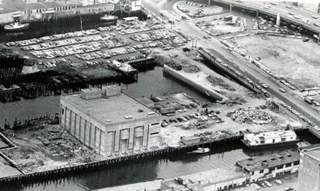
An ariel image of the aquarium under construction in 1968. You can see before the construction of the aquarium that the wharf area was very desolate, with no attractions or leisure spots. You can also see the Central Artery in the top right corner…
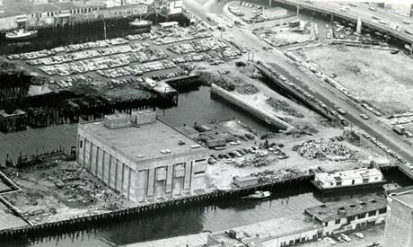
An ariel image of the aquarium under construction in 1968. You can see before the construction of the aquarium that the wharf area was very desolate, with no attractions or leisure spots. You can also see the Central Artery in the top right corner…

This image of Central Wharf shows the warehouses that use to dot the harbor side. No pedestrians, shops, or restaurants can be seen.

This image of Central Wharf shows the warehouses that use to dot the harbor side. No pedestrians, shops, or restaurants can be seen.