Bombay as an Economic Hub
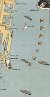
This map highlights examples of business opportunities in Bombay, especially the shipping and film industries, catering to the potential investor or businessman who might read this map. For one, the ports are oversized in this map, relative to today’s satellite images and other contemporary maps’ depictions of the same ports. This might be an aesthetic choice, but perhaps also a tool to emphasise Bombay’s role as a major port in the Indian subcontinent. The cartographer also includes some drawings of boats which, with the exception of a train at the top of the painting, are the only drawings which do not refer to static landmarks. Choosing to include the boat drawings is perhaps another sign of the cartographer’s intention to emphasise Bombay as a port city.

The film industry is also included in this drawing through small icons of video cameras. When reading the key in the bottom right of the map, “cinema” seems oddly out of place. Understandably, tourists need to know where the hotels, foreign exchange, and travel agencies are: these were probably necessary destinations for travel in 1958. It also makes sense to me for a guide map to highlight options for transportation: shipping and airlines. However, cinema really jumps out as an “optional” destination. Why include the video camera icons but not icons for restaurants or shops? Perhaps it makes sense because the film industry is so essential to Bombay’s identity. Bollywood was already a thriving force in the 50s, known and appreciated by viewers in the west.
Contrastingly, several other industries which were important to Bombay at that point in time, such as cloth mills, dye factories, and tobacco factories, are not emphasised in this map – perhaps because few tourists would have any reason to visit these places, but also because these secondary manufacturing industries do not align closely with the image of Bombay that the cartographer is trying to convey.