Browse Items (344 total)

http://dighist.fas.harvard.edu/courses/2015/HUM54/files/original/2efd99295c5e4241f3193ea514e7f6a7.png
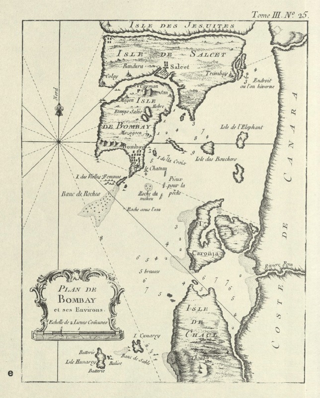
This map is eerily similar to the Bellin’s map drawn in 1764. The only discernable differences are that the orientation of the words is changed.
http://dighist.fas.harvard.edu/courses/2015/HUM54/files/original/3606b578739780f6b333ab88a3a3232f.png
This map is a map of Bombay's seven original islands created by Captain Jacques Bellin in 1764.
Thomas Kitchin drew the two maps: “A Map of the Countries round Surat and Bombay” and “A new and accurate Map of Bengal”) in 1783. The Kitchin map is at a different scape and was drawn by a man who did not travel to the area.
http://dighist.fas.harvard.edu/courses/2015/HUM54/files/original/59b1ef13d6cb5a609ac336445928808e.png
ii. The settlements are drawn in pictorially at the border of the Ile de Bombay. It may suggest that the Captain may have visited on land to the island and thought it was an important landmark for others traveling later to know of the settlements.
http://dighist.fas.harvard.edu/courses/2015/HUM54/files/original/63a2d4b26d5c530238d14589ea4e89db.png
The message suggests a safe space to anchor a place to spend the winter: “Endroit ou l’on hiverne” (place where one winters).
http://dighist.fas.harvard.edu/courses/2015/HUM54/files/original/0b526cc8b9944cfe2cf1b6ee84d8d132.png
Numbers are scattered around the sea, which relay the information of depths most likely in leagues as mentioned in the legend.

http://dighist.fas.harvard.edu/courses/2015/HUM54/files/original/07a437a23439843f911123528cfde582.JPG
The descriptions of the maps in the atlas, A Series of Early Printed Maps of India in Facsimile, written by Susan Gole. The chosen map refers to map 33. A comparison map is map 43 described later made by Kitchin.
http://dighist.fas.harvard.edu/courses/2015/HUM54/files/original/45c3d8beb456db6f3395346f08243cfd.JPG
The Introduction in the atlas, A Series of Early Printed Maps of India in Facsimile, written by Susan Gole.
http://dighist.fas.harvard.edu/courses/2015/HUM54/files/original/5426eb71dd311f609910c46133c12112.png
i. The chosen map is one made by the navigator Captain Jacques Nicolas Bellin (1703-1772) in 1764 and was published in 1980 in the atlas compiled by Susan Gole in New Delhi of “Early Printed Maps of India.” We will focus on the leftmost map titled…
http://dighist.fas.harvard.edu/courses/2015/HUM54/files/original/89f3f12cec7415f1826c3109cee93824.jpg
This is a map of the western coast of India in 1782
Output Formats

atom, dcmes-xml, json, omeka-xml, rss2