Hafen von Bombay, Reede von Bombay
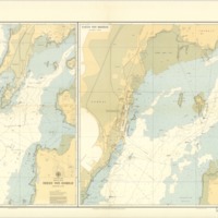
According to Mike Forester's The Lost art of Critical Map Reading, "Given [maps'] inherent ability to relate specific topics to the earth we live on, maps are often viewed as truth and fact, and are rarely challenged. However, at the same time maps are storytellers, providing rich illustrations and the ability for interpretation." This 1976 reprinted map of the "Arabisches meer, indische kuste, reede von Bombay, hafen von Bombay" or "The Arabian Sea, Indian Coast, Reede of Bombay, and Port of Bombay," seems to be a largely utilitarian. Published first in 1956, and then reprinted in 1976, the map was commissioned and reprinted by the Deutschen Hydrographischen Institut or German Hydrographic Institute in Hamburg during peacetime, after Indian independence from England. The map's combination of English and German reflects the trade relations between the three countries by 1956, and their continued trade relationships in 1976 when the map was reprinted. lacking the pomp, color, and historical or commercial destinations common to tourist and outsider maps, and the statistical information common to maps with an overt socio-political agenda, the map it presents as an objective, topigraphical, maritime map of the Mumbai Port and its surrounding land and seascapes, without room for creative decisions or alternatives.
Still, upon closer examination, the map's lack of avowed agenda, as well as its relative familiarity due to its similarity to maps we are used to provide cause for deeper scrutiny. Its mystery is in its familiarity, its subjective decisions hidden under a seemingly flare-less presentation. For whom was this map intended? What assumptions can we make about the intended viewer from the presentation of the map? And what was the map intended to tell its viewer about its subject? The map's collection of visual information provided through colors, lines, symbols and words describe a maritime view of Mumbai, designed for ships coming into and out of the Mumbai Port in the pre-digital maritime cartography age.
Forester, Mike. "The Lost Art of Critical Map Reading." Directions Magazine. N.p., 27 Mar. 2014. Web. 24 Nov. 2016.