Boundaries and Omission: Highlighting Another Side of the City

While Alfred-Duggan underscores the idea of Mumbai as a bustling touristic metropolis through the details and overall purpose of this map, certain aspects of his omissions also highlight another facet of the city, which is that there is extreme poverty coexisting with the city’s prosperity. This is especially salient through the cartographer’s chosen boundaries of the map. While the southern boundary, as discussed previously, highlights a touristic and globalized facet of the city, the northern boundary fulfills a similar purpose but also serves to highlight a more somber facet of the city. As seen in the figure to the left, Alfred-Duggan has omitted much of not only metropolitan but also suburban Mumbai in his map. The omitted area to the North represents a less metropolitan and urban area of the city, so it may be reasonable that the cartographer decided to omit these areas in a map intended for travelers of the city. However, when we analyze the areas that he omitted more closely, fascinating aspects of the city come to light.
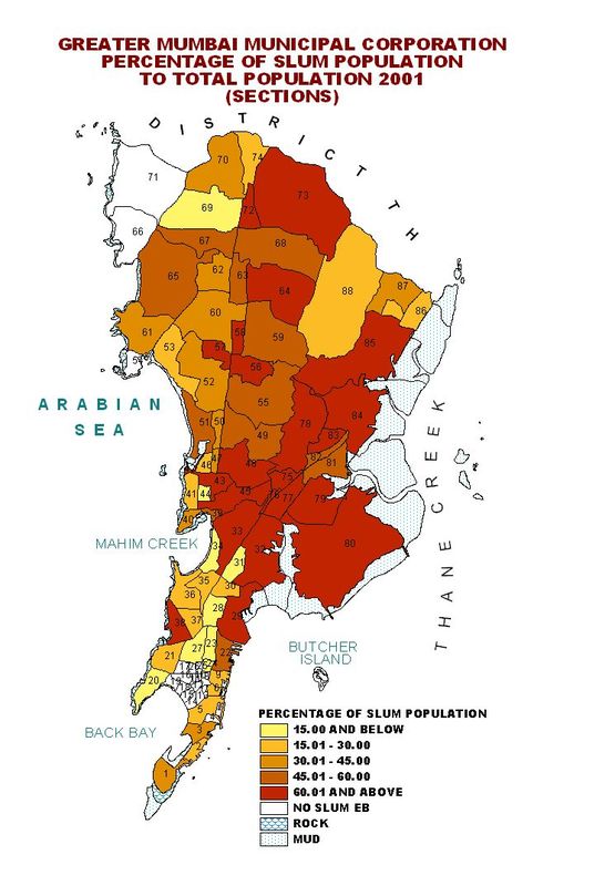
As seen in the comparable figure to the left, which depicts the percentage of slum populations in the various districts of Greater Mumbai, much of the omitted area to the north of the depicted coverage is composed of regions that have extremely high percentages of slum populations. There are large masses of red zones, representing areas with 60.01% or higher of slum populations throughout the Northern area above the boundary, and most of the covered region in the map is composed of regions with 45% and less or even no slums at all. While Alfred-Duggan’s omission of these slum areas, similar to his omission of the Southern tip of Mumbai, emphasize the touristic and prosperous facets of the city, the exclusion somehow also underscores the existence and prominence of these slum areas. As Patel highlights in his essay “The Making of Global City Regions: Mumbai: The Megacity of a Poor Country,” Mumbai is a city of simultaneous wealth and extreme poverty. He writes, “If the city hosts the best of India in terms of art, style, and finance, it is also a place where a large portion of the population lives on the margins of existence. Bombay, whether we call it modern, postmodern of global evokes images of decline- of infrastructure, manufacturing, and law and order. With more than 50% of its inhabitants living in slums of shanties where they have little access to water and sanitation, the name Bombay also conjures up the worst that contemporary India represents.” (1) With the extreme prevalence of these impoverished slum areas outside this metropolitan and prosperous area represented in the map, the cartographer’s omission simultaneously highlights Mumbai’s wealth and destitution. The omission highlights the idea that slums exist heavily outside the border between tourism and high class and the overcrowded low class.
Works Cited
1. Patel, Sujata. "Mumbai: The Mega-City of a Poor Country." The Blackwell City Reader (2002): 73-77.